The most mesmerizing attractions in the Southwest

The Southwest is home to some of the most breathtaking natural wonders in the world. This dazzling region of the country is a prime place to plan an adventurous, active, outdoorsy vacation. The scenery is so diverse out here that you can go from hiking amongst cacti to snowshoeing through a pine forest, all in the same day. Because attractions in the Southwest are so spread out, you really need to spend some time here to take it all in.

Hiking in Phoenix and snowshoeing in Flagstaff
Only in Arizona…one of the few places where you can ski/snowshoe and hike in the same day. From a mild 70 degree day hiking in the desert, to snowshoeing through pines – all within a 2 hr drive!

While the summers can be quite dry, sunny, and plain miserable with months of unending 100+ temps in most areas, the rest of the year is pretty moderate. Plus, there are many high altitude escapes which offer a convenient respite from the heat of the surrounding low desert areas.

For purposes of this list, I have considered Arizona, New Mexico, southern Utah, southern Nevada, and Western Colorado & Texas, as there are the states I feel most embody the Southwestern spirit in terms of landscape, culture, natural attractions, and food. Here are 50 mesmerizing sights to add to your Southwestern bucket list!

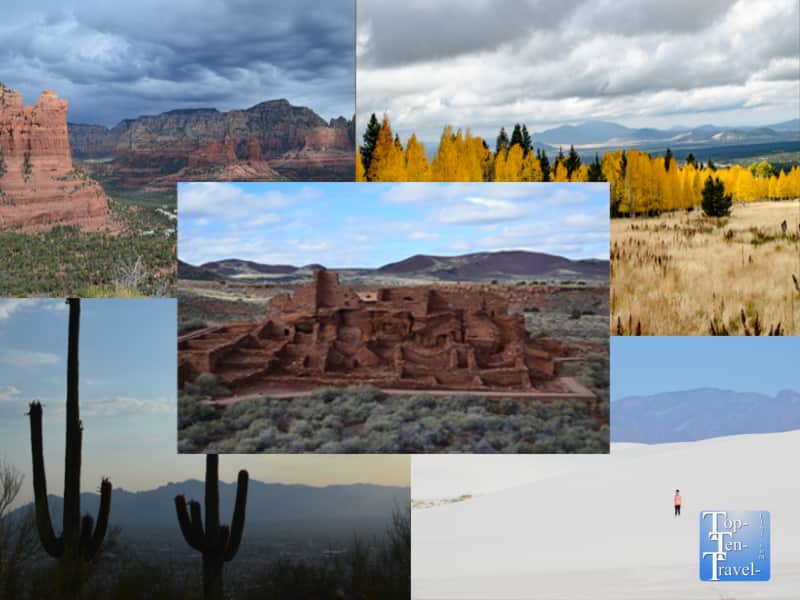
1. Oak Creek Canyon Scenic Drive

The scenic Oak Creek Canyon drive in Sedona

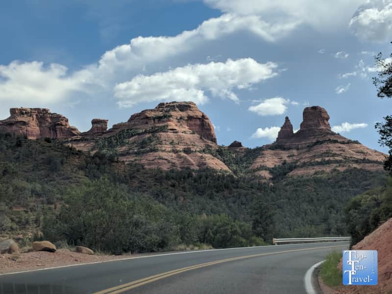
This enchanting 14 mile long river gorge lies in between the high altitude pine covered wilderness of Flagstaff and the colorful red rock wonderland of Sedona. Scenery is drop dead gorgeous for the entirety of the 14 mile drive. Ponderosa pines, leafy deciduous trees, gigantic colorful rock formations, and serene views of Oak Creek, one of the only perennial streams in Arizona, line the route. Numerous hikes, creekside strolls, swimming holes, scenic overlooks, restaurants, and authentic Native American craft markets can be enjoyed along the way.

Hiking alongside the creek, viewing the oaks and maples of the West Fork trail changing beautiful autumn hues, aweing at the red rocks dusted with a fresh layer of snow after a winter storm, sipping a coffee on the lovely tree covered patio of Indian Gardens on a beautiful cool summer morning – every season offers a new & exciting opportunity to see & do something different, the same of which cannot be said of the Sonoran Desert just 2 hours away.

This drive is very crowded due to the immense beauty & cooler spring/summer climate (about 20 degrees cooler than Phoenix year-round). Despite the crowds, Oak Creek Canyon is worthy of a visit anytime of the year.

Location: Northern Arizona along Rt 89a, in between Flagstaff & Sedona, 2 hrs north of Phoenix

More info and a full list of things to do along Oak Creek Canyon

2. Horseshoe Bend

Horseshoe Bend in Page, Arizona

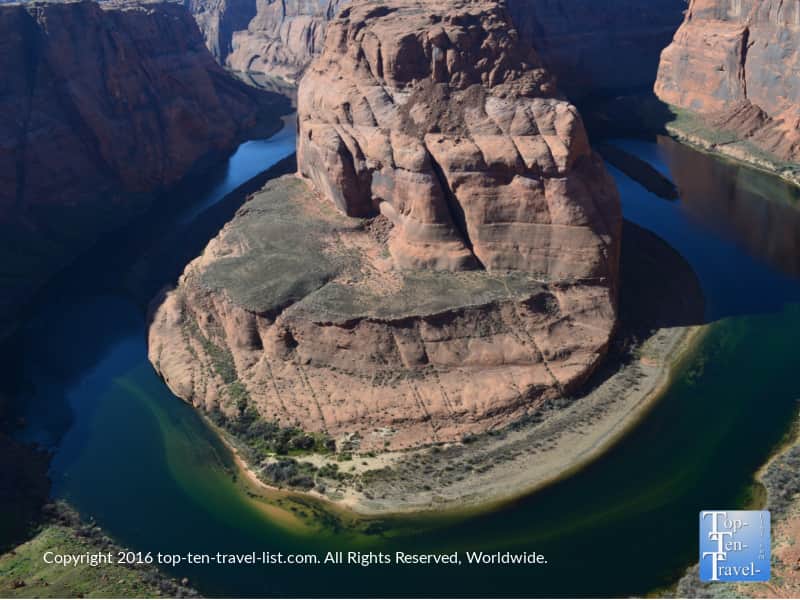
Horseshoe Bend is a really unique roadside geological wonder in Page, Arizona. It is definitely worth checking out if you happen to be traveling anywhere near the Northern Arizona/Southern Utah region. This is a great detour on the way to Zion or Bryce Canyon National Park. A short, but steep & sandy half mile trail will lead you to an interesting sandstone rock formation which takes on an odd horseshoe like shape as the beautiful Colorado River curves around it. The bright turquoise waters contrast brilliantly amongst the red rock formation. It’s no surprise that Horseshoe is one of the most photographed places in all of the Southwest.

Location: Page, Arizona (near the Utah border)

More info on Horseshoe Bend

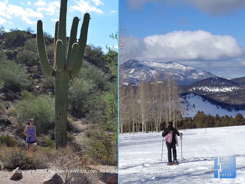
3. Saguaro National Park

Saguaro National Park

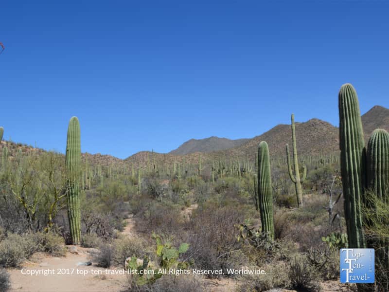
Saguaro National Park, which lies just a half hour outside of Tucson, Arizona, is one of the country’s most unique national parks. This gem is home to one of the highest concentrations of the visually spectacular (and very rare) Saguaro cactus. As this type of cactus is only native to the Sonoran Desert, it’s a rare sight, and thus, Saguaro NP is a worthy addition to your national park bucket list. Besides the Saguaro, you will find over 2 dozens species of cactus here, all of which are fascinating to observe up close in person.

There are 2 entrances to this massive park, and both are included with your admission ticket which is good for 7 days. The Rincon district features extraordinary views of the mountains, while the Tucson district is home to an especially dense concentration of Saguaros. If you only have time for 1 park, the Rincon is definitely the one to pick. This entrance features the most gorgeous paved scenic drive with numerous overlooks/trails along the route.

Both parks feature fabulous desert scenery, terrific mountain vistas, and scenic drives. Check out the event lineup which may include everything from a guided night hike to a presentation on how to harvest water from a cactus.

Location: About a half hour outside of Tucson

Fee: $25 per vehicle, $15 per person/bike

More info on Saguaro National Park

4. Walnut Canyon

The Island Trail at Walnut Canyon National Monument near Flagstaff, Arizona

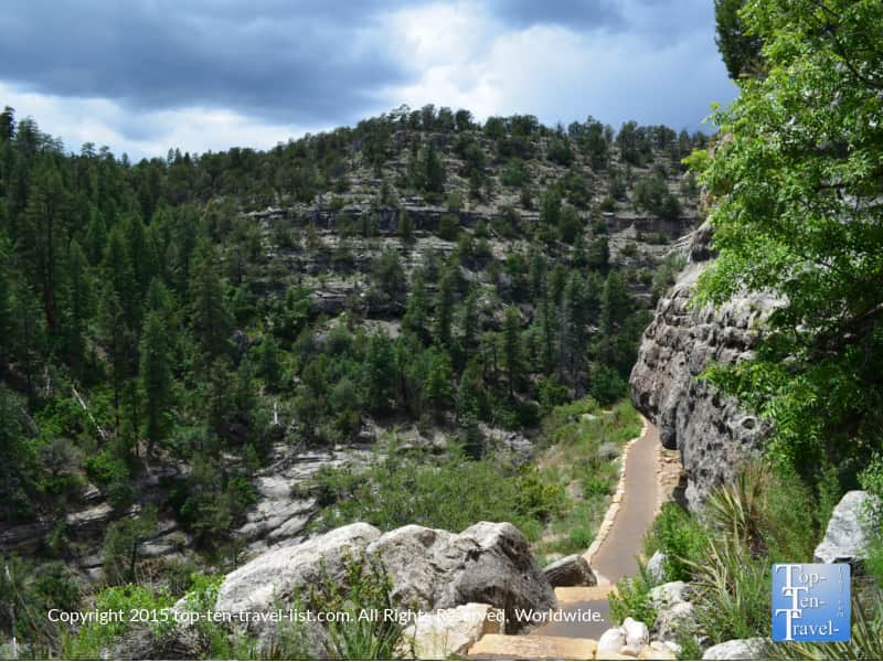
Walnut Canyon, a really interesting historic landmark located about 10 miles outside of Flagstaff, is highly regarded for its’ many well preserved cliff dwellings. It’s definitely worthy of a look if you happen to be vacationing or driving through the Northern Arizona region. This park is home to more than 80 ancient Sinagua cliff dwellings, about 20 of which you can view along the Island or Pubelo Ruins trail. The Sinagua tribes occupied the area from 1125-1250 AD and somehow managed to survive in an area with so little water (Sinagua means “mountains without water”).

The more difficult of the 2 trails, the Island, involves a 200+ stair climb where you not only pass more than 20 cliff dwellings, but you will also be treated to amazing overlooks of this massive 400 foot deep, 1/4 mile wide canyon. History buffs, nature lovers, & photographers should all appreciate the natural beauty and historical significance of Walnut Canyon.

Location: About 20 minutes outside of Flagstaff, Arizona

Fee: $25 per vehicle for a 7 day pass

More info on Walnut Canyon

5. Inner Basin

Aspens lining the Inner Basin trail in Flagstaff, Arizona

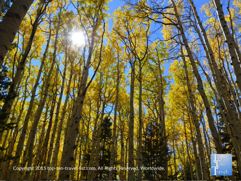
The Inner Basin is a high altitude hiking adventure which begins in Flagstaff’s gorgeous Lockett Meadow area. This trail travels into the heart of the beautiful San Francisco Peaks, the highest mountain range in Arizona. Breathtaking mountain scenery aside, this also happens to be one of the top leaf peeping trails in the country. Walking amongst the golden aspen groves on a crisp autumn day is spectacular. It’s odd to think of any place in Arizona as being a prime leaf peeping destination! However, Inner Basin’s foliage easily rivals anything found in New England.

This hike is quite a feat with a beginning altitude of 8600 feet and an elevation gain of nearly 1500 feet over the 1.7 mile out-and-back course. Nevertheless, it is well worth the climb for the amazing foliage and opportunity to stroll through breathtaking uninterrupted nature. Do not let the difficulty hold you back as you can simply go out to your comfort level and still enjoy plenty of autumn hues.

Location: Lockett Meadow in Flagstaff, Arizona

More info on the Inner Basin trail

6. The Painted Desert

Pretty views of the Painted Desert at the Petrified National Forest

The Painted Desert is a mesmerizing area of colorful buttes & badlands, encompassing a massive 93,000 acre span in the Four Corners region, stretching from the Grand Canyon to the Petrified National Forest. The best way to take in this amazingly unique landscape is by planning at visit to the Petrified National Forest, a very unique park which is home to one of the largest collections of petrified wood in the world.

The Painted Desert name arises from the fact that the rocks can be seen in a rainbow of colors. It really is a surreal place unlike any other. Various overlooks in the park will give you a glimpse of these gorgeous painted hills. However, the best way to fully take in the scenery is via a hike. The hikes here are so secluded that they take on a bit of an eerie nature, however, that’s part of the fascination. Both paved & off-the-beaten path trails for the more adventurous can be enjoyed. The Blue Mesa trail is a great easy 1 mile option for everyone. Avid hikers may want to look into a backcountry hike for the ultimate adventure.

Location: Northeastern Arizona near Holbrook

Fee: $25 per vehicle for a 7 day pass, $15 per person/bicycle

More info on the Petrified National Forest/Painted Desert

7. Durango Silverton Narrow Gauge Railroad

The Durango Silverton Narrow Gauge Railroad takes you on an exhilarating 45.2 mile route through the beautiful San Juan National Forest by way of a historic, coal-fired, steam powered train. The ride starts at an altitude of 6512ft at the Durango depot and follows a picturesque journey through the serene Colorado countryside alongside the gorgeous Animas River until reaching the beautiful small community of Silverton which, at 9318 feet, is one of the highest elevated towns in the US.

The majority of the ride takes you through a very remote area of the forest which is not easily accessible. Oftentimes, you will see wildlife right out your window. Waterfalls, canyons, pretty pine & aspen forests – the ride is pure nature at its’ best. Views are great anytime of year, although particularly thrilling come fall when the aspens turn the most brilliant shade of gold, and again during the winter when the mountains & pines are covered in a fresh blanket of snow.

There are numerous train classes available, and also a specialty open air car which is really nice during the warmer summer season although it sells out quickly! You have the option of taking a round trip train ride (3.5 hour ride each way with a 2 hour lunch stop in Silverton) or taking the train one way and a bus the other way. The former is actually the better option as you save time, plus you get to see new views as you travel by bus one-way on the incredibly scenic San Juan Highway (Highway 550).

Location: Southwestern Colorado (Durango)

More info on the Durango Silverton Narrow Gauge Railroad

8. Devil’s Bridge

Devil's Bridge hike in Sedona, Arizona

Devil’s Bridge is the largest and most fascinating of the many beautiful sandstone arches found in the Sedona area. A moderate hike of just under 4 miles round trip leads you to this magnificent natural wonder which is one of the most photographed sites out West. While the bridge looks very narrow from afar, it’s actually quite wide at about 5 feet. However, when you walk out and see the gigantic drop below you (about 50ft), it’s still quite a scary experience and definitely not for those scared of heights!

If you are brave enough to stroll across the arch, the panoramic red rock views are out-of-this-world. It’s a pretty exhilarating experience – definitely one for the bucket list! Plus, you can have someone across take your photo for a really cool memento of your trip. Even if you skip the bridge walk, the scenery for the entirety of the hike consist of jaw dropping red rock views. This is easily one of the most picturesque hikes in Sedona, which is no easy feat in an area loaded with top notch trails.

Location: Sedona, Arizona

More info on Devil’s Bridge

9. Desert Belle Cruise at Saguaro Lake

4 peaks mountain range seen from Saguaro Lake in Southern Arizona

One of the best ways to soak in the unique scenery of the Sonoran Desert is by taking a narrated cruise aboard the Desert Belle. Saguaro Lake, located less than an hour away from Mesa, is the most easily accessible and most gorgeous lake in Arizona. Named for the abundance of Saguaro cacti that line the shores, you will find no shortage of eclectic desert plant life here. Gorgeous mountain vistas (including Four Peaks – the highest point in the Phoenix metro area at 7659 ft) and plentiful wildlife sightings (a rare jaguar was actually sighted here a while back) will make the hour and a half cruise fly by.

This cruise is an ideal choice during the brutal summer months, when you still want to enjoy the desert scenery, yet it is way too hot to do anything outside. Because the cruise is air conditioned (arrive early to ensure an indoor seat!), you can still enjoy the enchanting desert scenery without risking heat exhaustion and dehydration on the trails. To get to the lake from Mesa, you will get to drive a portion of the incredibly scenic Apache Trail drive, which is loaded with fabulous views of the Superstition mountains.

Location: About an hour outside of Mesa Arizona

Fee: $25 per person ($17 kids)

More info on Saguaro Lake

10. Red Rock Canyon

Amazing scenery at Red Rock Canyon near Vegas

Who knew such gorgeous natural scenery could be found just a half hour from the man-made entertainment extravaganza of the country known as The Strip? Red Rock Canyon is easily one of the most picturesque places in the Southwest. No contest – it’s the best place to escape the clutter & congestion of The Strip, if only for a few hours to recharge and immerse yourself in beautiful natural surroundings.

Colorful rock formations surround you in every direction, whether you are enjoying the 13 mile long scenic drive, embarking on one of the many hikes, or simply relaxing and enjoying the views via a scenic overlook. Red Rock Canyon is one of Nevada’s treasures and easily missed by those who never venture off The Strip! If you have been to Vegas one too many times and you are seeking something new & interesting to do, a visit to Red Rock Canyon is a must!

Location: Las Vegas (about 20 minutes from the Strip)

Fee: $20 per vehicle, $5 per person/bike

More info on Red Rock Canyon

11. Pa’Rus trail at Zion National Park

The Pa'Rus trail at Zion National park

Zion National Park is one of the West’s most underrated national parks. With towering rock formations, lush plant life, and the serene Virgin river flowing through the park, the name Zion (which translates into a “place of peace” in Hebrew) really rings true. The Pa’Rus trail is the easiest trail within the park. Fortunately, it’s also one of the most scenic as it follows the course of the river and is lined by colorful rock formations on both sides.

The 3 mile long distance makes it a perfect choice for an easy bike ride or nature walk, and thus, suitable for all visitors no matter your fitness ability. Avid cyclists can choose to go further via connecting to the Zion canyon scenic drive and riding along the road (definitely recommended for the incredibly scenic views!).

Location: Just a few miles outside of Springdale, Utah

Fee: $35 per vehicle for a 7 day pass or $20 per person

More info on the Pa’Rus trail 

12. Aspen Nature Loop

Fall foliage along the Aspen Nature Loop in Flagstaff, Arizona

The beautiful high altitude Aspen Nature Loop at Arizona Snowbowl is one of the most spectacular hikes in gorgeous Flagstaff. Like Inner Basin, this one is also mesmerizing during the fall season as golden groves of aspens line much of the trail. Surprisingly, this trail remains isolated for much of the year despite the immense beauty.

The lack of crowds, big mountain views, and gorgeous drive up Snowbowl Rd are more reasons to specifically seek out this gorgeous trail. This adventure starts out around 8000 ft and follows a quaint quiet loop of just over 1.5 miles with a modest elevation gain of just 275 ft. Any nature lover/hiker staying in Flagstaff definitely needs to check out this beauty!

Location: Arizona Snowbowl – 7 miles outside of Flagstaff

More info on the Aspen Nature Loop

13. Grand Canyon South Rim

Hiking the South Kalibab trail at the South Rim of the Grand Canyon

A trip to the Grand Canyon should be on every nature lover, photographer, and hiker’s travel bucket list. It’s hard to pass up on one of the world’s most magnificent natural wonders, especially when there are numerous other national monuments, parks, and wonders within close vicinity which you can combine for one amazing trip. Quite surprisingly, the Grand Canyon is not one of the Seven World Wonders! Nevertheless, it’s still a worthy addition to any bucket list.

There are 2 entrances to the Grand Canyon, with the North Rim being the more peaceful and scenic section, and the South Rim being the more easily accessible and offering more amenities than the North Rim. If you can score a room at the historic El Tovar Lodge (which often sells out months in advance), this is the way to go as it is conveniently located right on the rim.

Taking a stroll along the 14 mile paved Rim trail, a rustic hiking adventure along the South Kalibab trail into the heart of the canyon, lunch at the El Tovar, and enjoying the vistas from Mather and Yavapai Point are the must-do’s on any South Rim trip. Adventure seekers must plan for a hike along the South Kalibab. The 1.5 mile hike to Skeleton Point is extremely difficult due to the steepness & high altitude. However, the views are simply out-of-this-world. The opportunity to take in the canyon scenery minus the crowds is truly an opportunity not to be missed.

Location: Northern Arizona

Fee: $35 per vehicle  for a 7 day pass or $20 per person/cyclist

More info on the Grand Canyon South Rim

14. Catalina State Park

Beautiful views at Catalina State Park in Tucson, Arizona

Catalina State Park, located in the quiet suburb of Oro Valley about 20 minutes north of Tucson, is one of the area’s hidden gems. Hands down, Catalina is one of the best places to hike in Southern Arizona due to the beautiful mountain scenery, abundance of cacti plants, and secluded trails. It’s rare to see more than a handful of people on any trail here so you can take all the time you want exploring the various desert plants without feeling like there are mounds of people on your back.

Towering vistas of the Santa Catalina mountains surround you on every trail. If you wish to enjoy the Sonoran Desert in a peaceful & beautiful setting, Catalina is an ideal choice. From an easy 2 mile nature stroll, to an all day adventure to Romero Pools, there’s a trail to suit every skill level. And compared to Saguaro National Park, entry is a bargain at just $7 per vehicle.

Location: Oro Valley, Arizona

Fee: $7 per vehicle or $3 per person/cyclist

More info on Catalina State Park

15. Chiricahua National Monument

Chiricahua National Monument in Southern Arizona

Chiricahua, known as “the wonderland of rocks,” is a hidden gem in southeastern Arizona. Due to the isolated nature, the park remains very uncrowded. The various hoodoos and weird rock formations really give this park a unique look, even for Arizona where you can find all sorts of interesting rock formations throughout the state. The park is also known for its’ large number of balancing rocks. Basically, there are big boulders which sit upon other large rocks. An 8 mile paved drive and over 17 miles of hiking trails give you plenty to do to justify a day trip from Tucson or anywhere else in the state.

Location: Wilcox, Arizona

There is no fee!

More info on Chiricahua National Monument

16. Tonto Natural Bridge State Park

Largest natural travertine bridge in Payson, Arizona

Tonto Natural Bridge State Park is home to the world’s largest natural travertine bridge. This unique park is located in Payson, Arizona, a small town in the central portion of the state. Asides from the bridge, the park is unique in that the high altitude (about 5000 ft) and abundance of deciduous trees make it a popular place for leaf peepers in the fall.

The cooler summer weather makes the park very popular with Southern Arizona residents fleeing the low desert heat. Many of the trails are shady and the overall landscape differs greatly from the southern portion of Arizona. Natural pools and a seasonal waterfall allow for a rare glimpse of water in the desert. While you are in the vicinity, you should also plan for a leisurely drive along the beautiful Mongollon Rim Rd. This 38 mile scenic drive is known for its’ gorgeous sandstone formations & pine forests.

Location: near Payson, Arizona

More info on Tonto Natural Bridge State Park

17. Sunset-Wupatki Scenic Drive

Beautiful views of the San Francisco Peaks from Bonito Meadow near Flagstaff, Arizona

Flagstaff offers amazing proximity to a number of fantastic natural attractions, landing it the nickname “the city of 7 wonders.” Sunset Crater (the 900 year old remains of a volcano) and Wupatki National Monument (a 12th century Sinagua cliff dwelling with over 100 rooms) are just 2 of these amazing sights. Both easily accessed via a short day trip. These 2 unique national wonders connect via a picturesque 36 mile paved drive. On this incredible drive, very diverse landscapes including ponderosa pine forests, colorful cinder cones, and the sparse desert plains come into view.

The drive is peaceful and far away from any civilization, so really the perfect place to enjoy uninterrupted nature. A magnificent overlook known as Bonito Meadow is the highlight of this drive. Here you will be treated to a gorgeous view of San Francisco Peaks and Sunset Crater, and if you time your visit right, thousands of yellow wildflowers. This drive also happens to be one of the best for stargazing due to the absence of light pollution and the remote nature.

Location: Forest Rd 345 about 35 minutes outside of Flagstaff

18. Slate Mountain trail

Stunning views of the San Francisco Peaks from the Slate Mountain trail near Flagstaff, Arizona

The Slate Mountain trail is a moderately difficult trek which leads you to the most amazing overlook of the San Francisco Peaks. With the immense beauty of this trail, it’s crazy how isolated it remains. Perhaps, this is because tourists do not want to make the 35 mile drive outside of Flagstaff. The trail involves a challenging 2+ mile climb to the summit, however, the gradual switchbacks and lack of big boulders to scramble up make it feel a bit easier than it appears at first glance.

It helps to adjust to the altitude for a day or 2 around town before embarking on this trail as the elevation climbs from 7300 feet all the way up to 8200. Of course, the hard climb is well worth it in this case for the best views of Arizona’s highest mountain range. This hike rewards with gigantic views as well as peace and quiet as you will be in absolute solitude. Uninterrupted nature at it’s best – this one is a true gem!

Location: About 30 miles outside of Flagstaff, off of Hwy 180

More info on Slate Mountain

19. Mt Lemmon Scenic Byway

Saguaro cactus along the Mt Lemmon Scenic Byway near Tucson, Arizona

Mt Lemmon is one of many unique Sky Islands in the state of Arizona. A Sky Island is an isolated high altitude mountain area surrounded by a lower altitude area. The town of Summerhaven at the base of Mt Lemmon sits at an elevation of 7000 ft. At this high up, summer temps are at least 20 degrees cooler than the surrounding desert. The best part about visiting Mt Lemmon is the 30 mile picturesque drive up the Catalina Scenic Byway. This drive begins near the rolling cacti covered hills of Tucson and ends in a forest of ponderosa pines.

Views are very dramatic the entire way up with tons of Saguaro cacti near the start, ancient hoodoos, breathtaking views of the mountains, and eventually gorgeous towering pines. Along the way, you will have access to hikes, picnicking areas, scenic overlooks, and even a small lake. At the end of the drive, you can choose amongst a variety of trails, enjoy shady picnic areas, take a scenic chairlift ride, and enjoy breakfast or lunch amongst the pines and aspens. Fall foliage lines many trails in autumn. And if you are a skier, you will want to check out the country’s southernmost ski resort.

Location: The drive starts right outside of Tucson

More info on the Mt Lemmon area

20. Treasure Falls

Treasure Falls waterfall in Pagosa Springs, Colorado

Treasure Falls is a gorgeous 105 foot tall 2 tier waterfall in the San Juan National Forest in Pagosa Springs, a quaint Colorado town in the Four Corners region. Few spectacular waterfalls are as easily accessible as Treasure Falls which requires a simple (though quite steep 300 foot climb) trek of just a quarter of a mile. The hike is peaceful and beautiful as tall pine forests comprise the background.

The name Treasure Falls comes from a local legend of a buried chest of gold hidden somewhere within the mountains. Whether or not any hidden gold remains to be found, the hike itself really is the hidden treasure. This area is home to so many gorgeous hikes, is just an hour away from the breathtaking Durango & Silverton Railroad, and is home to the best hot springs resort in the country. Pagosa is a must visit for nature lovers & hikers.

Location: Just a few miles outside of Pagosa Springs, Colorado

More info on the Treasure Falls hike

21. Red Rock State Park

Gorgeous views at Red Rock State Park in Sedona, Arizona

Red Rock State Park is a hidden gem in the red rock wonderland of Sedona. This gorgeous well-maintained state park is a great place for new tourists as there are a number of easy-moderate well marked trails which all offer surprisingly gorgeous views for so little effort compared to many of the harder treks in town. Most of the trails here feel more like nature walks rather than hikes. Even better, most are considerably shady for Sedona, making a hike here more tolerable during the hot summer season.

Red Rock is located far away from the touristy, congested Uptown area. Thus, you can easily get lost in nature. It’s easily one of the most gorgeous areas in the country. You also get to drive on the beautiful Red Rock Scenic Byway to get here, and the drive becomes more secluded & scenic the further you go on. For casual hikers looking to keep it easy without sacrificing the views, Red Rock State Park is the top choice in town. Be on the lookout for interesting programs throughout the year including a guided stargazing walk!

Location: Sedona, Arizona

More info on Red Rock State Park

22. Arizona Snowbowl Summer Chairlift Ride

Scenic views from the Arizona Snowbowl scenic chairlift ride in Flagstaff, Arizona

Arizona Snowbowl, a large and very popular ski resort in Northern Arizona, offers a picturesque summer chairlift ride up to “the coolest place in Arizona.” As you begin your high altitude lift from 7000 feet all the way up to 11,500 feet gazing down at all the towering pine trees, it’s really hard to believe that you are still in Arizona! Average summer temps at the overlook barely crawl out of the 60’s! How’s that for a striking deviation from the 110+ temps that Phoenix sees on a regular basis during the prime of summer?!

Location: Snowbowl about 7 miles outside of Flagstaff

More info on the Scenic Chairlift ride

23. Emerald Pools at Zion National Park

Gorgeous scenery along the Emerald Pools trail at Zion National Park in Utah

There are 3 picturesque waterfalls that are easily accessible via a moderate hike at Zion National Park. Of all the great trails at Zion, the combined Lower, Middle, & Upper Emerald Pools hike is by far the most mesmerizing. It’s also not all that difficult considering the fantastic scenery. Not only do you get to see 3 waterfalls, but you also get to cross the tranquil Virgin River. And of course, amazing vistas of the red rock formations keep you company throughout.

While the waterfalls are far from the most jaw dropping in the country, they are beautiful for the desert and the overall scenery of the hike is just stunning. The trail is shady, peaceful, and simply a perfect way to spend a few hours in a beautiful and rare natural setting. The trek to the Upper Falls is 3 miles round-trip and moderate in intensity. However, if you are looking for something a bit easier you can go out to the middle falls which is just 2 miles.

Location: Zion National Park (just outside of Springdale, Utah)

More info on the Emerald Pools trail

24. Sandia Peak Tramway

A gorgeous sunset over the Sandia mountains in Albuquerque, New Mexico

The towering Sandia mountains (highest peak is Sandia Crest at 10, 678 ft) provide a striking backdrop to the relaxed Southwestern desert city of Albuquerque. Sandia translates into “watermelon” in Spanish, and thus, it is believed that the name for this grand mountain range came from the brilliant reddish glow that appears over the mountains at sunset. The best way to take in a beautiful Albuquerque sunset is via the Sandia Peak Tramway. This popular enclosed gondola ride travels up to a picturesque viewpoint at an altitude of over 10,378 feet. At 2.7 miles in length, it’s the longest tram ride in the US.

From here, you can hike several trails, dine at a mountainside restaurant, or simply relax, take in the sunset and enjoy the ride down. New Mexico has been appropriately nicknamed “the Land of Enchantment” and gazing out upon all the uninterrupted nature below sure is an enchanting desert experience. If you are in the vicinity, it’s worth a ride for the spectacular panoramic view of the Rio Grande Valley.

Location: Albuquerque, New Mexico

More info on the Sandia Peak Tramway

25. The Arizona Trail

Gorgeous fall foliage along the Arizona trail in Flagstaff, Arizona

The Arizona trail is a lengthy 800 mile trail which begins at the Coronado National Monument near the Arizona-Mexico border and continues on all the way to the Utah border. The trail is very diverse as the scenery differs drastically in southern vs. northern Arizona. Biking, hiking, and even cross country skiing are popular seasonal activities along northern sections of the trail.

There are 43 different trailheads giving you plenty of options to explore the diverse terrain. The most scenic portion of the trail (passage 34 The San Fran Peaks – a 35 mile section of the trail) can be accessed via an area known as Aspen Corner.

About 6.5 miles up Snowbowl Rd you will arrive at Aspen Corner and from here you can easily connect to the Arizona trail. Simply go out to your comfort level for a wonderfully scenic high altitude adventure through the towering ponderosa pines. Bright golden aspens will surround you in every direction if you time your visit right at the peak of fall (which you should as this trail is amazing during peak fall foliage season!).

Location: 6.5 miles up Snowbowl Rd. just outside of Flagstaff, Arizona

26. Red Rock Scenic Byway

Red Rock Scenic Byway in Sedona, Arizona

Red Rock Scenic Byway is another breathtaking drive in Sedona, and although crowded, not nearly as popular as Oak Creek. This one is jam packed with red rock views although it does not offer the respite from the heat, nor the leafy trees and swimming holes of Oak Creek. What it does offer is a glimpse of many of Sedona’s most famous rock formations. Interesting, all rocks are named after the shape they resemble. Numerous hikes, overlooks, and attractions can be found along this 13 mile journey. So give yourself plenty of time to explore!

Directly on the route you will find the wonderful Chapel of the Holy Cross, the Little Horse trail, and the Bell Rock vortex (a vortex is an area of natural intense healing energy-more on that below) known to be a hotspot of UFO activity. Avoid this drive on holiday weekends and on Sundays when Phoenix daytrippers head back home. Do plan your drive early in the morning or on a weekday if possible to fully take advantage of the incredible scenery without massive crowds!

Location: SR 179 Sedona

27. Chapel of the Holy Cross

Amazing views from the Chapel of the Holy Cross in Sedona, Arizona

For truly awe-inspiring views head over to the Chapel of the Holy Cross, a unique Roman Catholic church built in between 2 massive red rock formations. This was rightfully so voted as one of the top man-made wonders in Arizona. Really, this is a hard feat as the state is home to many incredible sights, both natural & man-made. The architecture inside is incredible (a student of Frank Lloyd Wright designed the place) but the jaw dropping views right outside the Chapel doors is what draws thousands and thousands of tourists from around the world each year to take in the majestic red rock landscapes.

The Chapel is one of Sedona’s most powerful vortex sites. A vortex site is an area which supposedly has a lot of positive natural energy. Many visitors claim to feel rejuvenated after visiting these sites. There are several hikes in the area also reported to harvest strong vortex energies and you can even sign up for a special tour of the various vortex sites.

Location: Sedona, Arizona

More info on the Chapel of the Holy Cross

28. Madera Canyon

Scenic views hiking Madera Canyon in Arizona

Madera Canyon, a picturesque canyon in the Santa Rita Mountains within the Coronado National Forest of Southern Arizona, is one of the best places in the country for birdwatching. While the best birdwatching distinction is debatable, Madera is a great daytrip from Tucson. Madera sits at an elevation of around 5000 ft, and thus, is popular with Tucson residents looking to escape the continuous 100+ degree summer heat.

Pretty pine and deciduous trees line all the trails. Views of the surrounding mountains add a bit of excitement. You may even see some wildlife if you head out early in the morning. Madera is a great place to escape the heat and congestion of Tucson with opportunities to hike, birdwatch, & picnic in a pretty forested setting.

Location: 25 miles Southeast of Tucson

29. Doe Mountain

Incredible views at the summit of Doe Mountain in Sedona, Arizona

Few trails offer such world-class views in exchange for as short of a hike as Doe Mountain does in Sedona. In exchange for nothing more than a moderately steep climb of just 0.7 miles, you are rewarded with the most enchanting 360 degree red rock vistas. The views from atop the mesa are just incredible. You can stroll around a bit more here taking in the exotic plant life and enjoying a bird’s eye view of the area. This gem of a trail should be near the top of every hiker and photographer’s Arizona to-do list!

Location: Sedona, Arizona

More info on Doe Mountain

30. Watson Lake

Watson Lake in Prescott, Arizona

It’s rare to find any water in Arizona, so any lake (man-made or not) is a treasure. Prescott, a small but growing community in North Central Arizona, is home to 3 decent man-made lakes. The most scenic is beautiful Watson Lake which is home to some interesting looking rock formations called the Granite Dells. As a result of the isolated location, this lake feels like a true oasis in the middle of a dry desert.

Running right next to the lake is one of Arizona’s only rail trails, the flat and easy 4 mile long Peavine National Recreational trail. This path is a great way to get in a long bike ride or run in a scenic rare-for- Arizona lakeside setting. There are also some nice moderate hiking trails which overlook the lake. Renting a kayak or canoe for the day is yet another option.

Location: Prescott, Arizona

More info on Watson Lake

31. White Sands National Monument

Lost in the sand dunes at White Sands National Monument in New Mexico

White Sands is one of the most fascinating places to put on your Western bucket list. With glistening white sand dunes contrasting against the brilliant blue cloudless desert sky, it really is a surreal place. If you arrive here early enough in the morning before the crowds hit, it really is an exhilarating experience to stand alone on top of a sand dune, seemingly millions of miles away from any civilization.

A long time ago the desert area that stands today was covered by a lake in which layers of gypsum sand were deposited at the bottom. It is unusual for the gypsum to remain as it is normally soluble. However, it is theorized that gypsum was created faster than it could be dissolved.  The result is rare gypsum sand dunes. The hills are fun to walk up and down on your bare feet as gypsum does not reflect the sun even when the temps exceed 100, which they regularly do during the summer. Or bring with a sled and pretend like a winter storm just passed the desert!

Location: South central New Mexico near Alamogordo

More info on White Sands

32. McDowell Sonoran Preserve

Beautiful desert scenery at the Scottsdale McDowell Sonoran Preserve

While hiking Camelback Mountain is often touted as the must-do in the Phoenix area, in all reality, this hike is very difficult and also very crowded much of the time. My preferred alternative is the gorgeous trail system at Scottsdale’s McDowell Sonoran Preserve. First off, the trails here receive little foot traffic – rather at most times they are actually quite desolate. Second, the views of the mountains are outstanding. Third, there are a diversity of trails, so you can pick from easy to hard, long to short, etc. depending on how far you want to go out on any particular day.

Location: Scottsdale, Arizona

More info on the McDowell Sonoran Preserve

33. Wupatki National Monument

Wupatki National Monument in Northern Arizona

Wupatki is a 100 room, very well preserved pueblo ruin found just outside of Flagstaff, Arizona. Wupatki means “tall house” in the Hopi language and it was the largest building for 50 miles. The gorgeous red sandstone color of the pueblo stands out brilliantly amongst the blue skies of the Arizona desert. The ancient Sinagua lived here approx. between 1010 and 1100 AD following the eruption of nearby Sunset Crater. There is something enchanting about visiting these ruins. What a strange experience being in complete isolation in the desert, while imagining what life was like here so long ago.

A self-guided tour leads you past the main dwelling and several other unusual sites including a mysterious blowhole which functions as a natural vacuum – blowing air out when outside air is warmer, and sucking in air when it is cooler outside. Historians believe the blowhole may have been used as a natural heater/air conditioner or as a weather predictor. The blowhole was also thought to have spiritual purposes for the Hopi who tied the feature to the wind god, Yaponcha.

Location: About 20 minutes outside of Flagstaff, Arizona

More info on Wupatki

34. Watchman trail at Zion National Park

Stunning views from the Watchman Trail at Zion National Park in Utah

The Watchman is another incredible trail at Zion, this one involving a gradual but steep uphill climb which ends with spectacular views in every direction. The great thing about the Watchman Trail is that is does not see nearly as much traffic (especially so early in the morning) so hiking the trail is a nice solitary experience in which you feel like you get to take in the wonderful views all to yourself. Asides from wonderful views of the rock formations, the trail crosses the quaint river at several points. Mule deer and bighorn sheep often come out at dawn.

Location: Zion National Park near Springdale, Utah

35. Mission San Xavier del Bac

Mission San Xavier del Bac in Tucson, Arizona

Mission San Xavier del Bac, a gorgeous Spanish Catholic mission located about a half hour south of Tucson, is know as “the White Dove of the Desert.” It is considered to be the finest example of Spanish colonial architecture in the US. This magnificent architectural building is the oldest standing European structure in Arizona. Both the inside and the outside design are incredible. The interior features ornate statues and paintings. If you happen to be staying in Tucson or traveling anywhere in Southern Arizona, it’s worth a look. Open for self guided tours whenever an event/mass is not in schedule.

Location: 10 miles south of Tucson, Arizona

36. Trestle Recreation Area

Mexican Canyon Trestle in Cloudcroft, New Mexico

In the beautiful small mountain community of Cloudcroft, New Mexico lies the Lincoln National Forest, the perfect high altitude recreational area to escape the heat of the surrounding desert towns. This pine tree oasis offers a number of very scenic hikes in a beautiful woodsy setting that you will not find in the surrounding desert lowlands of southern New Mexico. The elevation of this area is 8000 feet which means hiking is more strenuous on one hand, while on the other hand the temps remain cooler in the summer.

The trestle recreation area includes 6 trails, ranging from a quarter of a mile to an 8 mile loop. The Cloud Climbing Trestle trail is a nice choice as it is just 1.2 miles in length and offers great views of the surrounding mountains, and also the Mexican Canyon Trestle. This wooden trestle was built in 1899 by the Alamogordo and Sacramento Mountain Railroad to access lumber in the forest. The trestle is 323 feet long and sits 52 feet above the canyon floor.

To get to the Trestle Recreation area, you will take the gorgeous State Route 244 which is an activity in and of itself as one of the more scenic drives in the Southwest.

Location: Cloudcroft, New Mexico

37. Cookstove Trail

Gorgeous views from the Cookstove Trail along Oak Creek Canyon in Sedona, Arizona

Well hidden amongst the dense trees along the beautiful Oak Creek Canyon drive in Northern Arizona lies one of the state’s most magnificent trails. The steep challenging Cookstove trail leads you on a scramble up to a breathtaking overlook of the area. The hike is just 0.7 miles but tough. The steep nature of the hike and high elevation combine to make this one of the area’s harder hikes. Thus, only advanced hikers should attempt this one. The payoff for your effort is a mesmerizing vista of the pine covered canyons. It’s crazy to think that this marvelous dense forested area lies just 2 hours north of Phoenix!

Location: Oak Creek Canyon drive (hwy 89) near milepost 387

More info on the Cookstove Trail

38. Dripping Springs Natural Area

Dripping Springs Natural Area in Las Cruces, New Mexico

Dripping Springs is a gorgeous trail right outside of Las Cruces, New Mexico. Beautiful as it is, the area also holds some interesting historical significance. The beautiful Organ Mountains provide the most spectacular backdrop for this 1.5 mile out-and-back hike. The organ mountains were named as so for their steep, needle like spires which resemble organ pipes. Wildlife is abundant particularly desert mule deer and coyotes, however, a rare mountain lion sighting is not unheard of. The peace and quiet out here in the middle of nowhere in the southern New Mexico desert alone is enough to justify looking into this trail.

The small waterfall at the end and old sanatorium ruins from the early 1900’s are just extra bonuses you will come across while hiking this wonderful trail. Boyd’s sanatorium was once used to house tuberculosis patients and the abandoned building is both fascinating and creepy. I wouldn’t be surprised if the ruins are now haunted. This area is pretty secluded, and thus, the trail remains quiet. And the remote drive to get out here is as picturesque as the trail itself. In fact, I found myself hopping in and out of the car to take many pictures – fortunately there is not much traffic out this way!

Location: Las Cruces, New Mexico

More things to do near Las Cruces

39. Hidden Canyon Bowen Loop

Bowen Hidden Canyon trail at the JW Marriott Starr Pass Resort in Tucson, Arizona

Hidden amongst the beautiful Saguaro cacti covered hills near the luxurious JW Marriott resort at Starr Pass in Tucson lies a beautiful easy 2 mile loop trail known as the Hidden Canyon Bowen loop. For those seeking to explore the desert in a solitary setting far away from the strip malls and tourist crowds, the Hidden Canyon Bowen Loop is the place to do so.

This incredible trail, which is located within the beautiful Tucson mountains, features unending views of the spectacular Saguaro as well as many other forms of desert plant life. It’s one of the best places to see bobcats in the wild, especially really early in the morning. You must be careful driving near the resort early as they are prone to cross the road quickly. Despite the easy terrain, hiking this trail is definitely not recommended in the summer due to the intense heat & lack of shade! Likewise for all other desert hikes!

Location: Tucson, Arizona

More info on the Hidden Canyon Bowel Loop

40. San Juan National Forest

The beautiful San Juan National Forest in Southwestern Colorado

The San Juan National Forest is a massive 1.8 million acre forest in Southwestern Colorado. The scenery is very diverse, ranging from high desert mesas, canyons, wooded forests, waterfalls, and high alpine meadows depending on the region. If you can make it here in the fall, the colors really are brilliant as there are tons of aspens in the area. The San Juan Skyway is one incredibly picturesque drive in the area.

Hiking and mountain biking are the most commonly enjoyed summer activities throughout the forest. Additionally, snowshoeing and cross country skiing through a wintry wonderland setting really is an exhilarating & solitary experience for those who love nature. For those seeking more relaxation, a horseback ride through the wilderness is a great way to take in a lot of scenery in a short period of time, particularly if you are on vacation with a limited timeframe.

Location: Southwestern Colorado

More info about San Juan Forest

41. Buffalo Park

Beautiful scenery after a winter storm at Buffalo Park in Flagstaff, Arizona

Buffalo Park is a beautiful year-round recreational park in Flagstaff, Arizona. From hiking in the cool summer months, to spring bike riding, to cross country skiing after a big winter storm, this park is the picture-perfect destination for any outdoor lover. Both locals and tourists flock to this park for the amazing views of the San Francisco Peaks and Mt. Elden.

There are a number of trails here including an easy 2 mile loop which is great for jogging, bike riding, or snowshoeing after a big winter storm. Buffalo is a picture-perfect winter wonderland after a huge storm, of which Flagstaff sees plenty of as one of the snowiest cities in the US (At 7000 ft, Flagstaff sees over 200 inches of snow per year!).

Location: Flagstaff, Arizona

More info about Buffalo Park

42. Tumanoc Hill

Tumanoc hill in Tucson, Arizona

Hiking Tumanoc hill is the iconic must-do experience in Tucson. This laid-back desert city is home to so many wonderful hikes. The best-of-the-best involves a steep 700 foot climb up Tumanoc Hill – owned for research use by the University of Arizona. After all your hard effort, you will be treated to a bird’s eye view of the city and surrounding mountains.

Note that there is no shade, so you will want to get up early for this one! Fortunately, it is open to the public for hiking from 4am-10pm. Setting your alarm clock super early will ensure that you beat both the crowds and the heat! And definitely stop by nearby Seis Kitchen for the most amazing breakfast tacos!

Location: Tucson, Arizona

More info on Tumanoc Hill

43. Honeybee Canyon

The beautiful Honeybee Canyon trail in Oro Valley, Arizona

Honeybee Canyon is a gorgeous hiking area in Oro Valley, a suburb located just north of Tucson. Although located in the midst of a sprawling suburb, the hiking here is very desolate and the views are outstanding. A short loop of just over 2 miles will take you through strands of cacti and eventually onto an overlook of the stunning Catalina Mountains range.

Location: Oro Valley, Arizona

44. City of Rocks

City of Rocks in New Mexico

City of Rocks is a really strange and fascinating place which basically appears out of nowhere in the middle of the barren New Mexico desert. Located in between the small cities of Deming and Silver City, City of Rocks is a great daytrip if you find yourself traveling near either of these cities. The erosion from a volcano which erupted 34.9 million years ago created the unusual rock formations which stand today. These rocks are only found in about 6 places worldwide.

The uniquely shaped rocks really standout in contrast to the flat surrounding desert. Some of these rocks are 40 feet tall so they really pop out against the desert landscape. The rocks are found in groups and separated by paths which resemble city streets, thus the decision to name this national monument the City of Rocks.

Location: Deming, New Mexico

More info on City of Rocks

45. Teacup/Sugarloaf Summit

The beautiful Teacup/Sugarloaf Summit hiking trail in Sedona, Arizona

Hundreds of miles of gorgeous trails can be enjoyed in Sedona. The Teacup/Sugarloaf combined 2 mile loop is one of the most scenic and convenient as it is located just minutes from the touristy Uptown section of town. This one is the best bang-for-your-buck hikes in town considering the relatively easy terrain in exchange for otherworldly views from atop the Sugarloaf summit. If you are looking to keep it relatively easy without sacrificing the jaw dropping red rock views, look no further than the Teacup trail, named as so for its’ unique standout rock formation.

Location: Sedona, Arizona

More info on the Teacup/Sugarloaf trail

46. Catwalk National Recreation Area

Catwalk National Recreation Area in New Mexico

The Catwalk is an interesting daytrip to consider if you find yourself staying in or traveling near Silver City, New Mexico. The Catwalk Recreation Area is located within the Mogollon Mountains of of Southern New Mexico. The area was established in 1889 when when gold and silver deposits were discovered in the mountains above the creek.

The name Catwalk comes from the original plank walkway placed atop the steel pipe that once brought water to the ore processing plant. The plank is suspended about 12 feet above Whitewater Creek as it winds through a gorgeous canyon. As you look down you’ll see a few small waterfalls. The trail was originally much longer but due to a fire was rebuilt and now stands at an easy 1/2 mile. The creek flows year-round and is a welcome change from the barrenness of the desert. And the drive from Silver City is an attraction in itself -very peaceful & scenic!

Location: Near Glenwood, New Mexico

47. Soldier’s Pass

Soldier's Pass trail in Sedona, Arizona

Soldier’s Pass is one of the most interesting of Sedona hikes due to a rare combination of natural features. On this 2.5 mile out-and-back trail, you will come across a number of unique sights including natural sandstone arches, Sedona’s most active sinkhole, and a series of cascading natural pools known as “7 sacred pools.” The hike is very beautiful with diverse scenery ranging from towering red rock formations to the serene and heavily treed red rock secret wilderness.

Location: Sedona, Arizona

More info on the Soldier’s Pass trail

48. Bear Jaw

Golden leaves along the Bear Jaw trail in Flagstaff, Arizona

The Bear Jaw-Abineau Loop is an incredible high altitude hike in Flagstaff which is outstanding anytime of the year, but even more jaw dropping during the fall season. The road to get to the trailhead is very rough (4WD recommended), however, this hike is worth any hassle. The combined loop is about 7 miles and involves a very steep climb with an elevation gain of nearly 2000 ft.

You will pass beautiful forested canyons intermixed with pines and aspens which turn a brilliant gold in the fall. This is one of the best spots in the Peaks to see black bears. The trail begins at an elevation of 8510 feet, making this one of the hardest trails in town when you consider the distance plus altitude. If you are looking for something a bit easier you can opt to skip the full loop in favor of the 2 mile out-and back trek to Bear Jaw, which will still be pretty difficult, but nothing as strenuous and time consuming as the 4-5 hour full loop.

Location: Flagstaff, Arizona

More info on the Bear Jaw-Abineau Loop

49. West Fork

Rare snow seen on Sedona's red rock formations along the West Fork Trail

West Fork is a tranquil trail running along the perennial Oak Creek near Sedona, Arizona. Although this trail is hidden amongst the dense trees, it is very popular with Phoenix locals fleeing the summer heat. In autumn, leaf peepers arrive in droves to view the beautiful traditional fall foliage. Bright hues of gold and red line every inch of the trail. Besides serene views of leafy trees, the trail features amazing red rock views and 13 fun & slightly challenging creek crossings. It’s one of the most popular trails within the Coconino National Forest for good reason.

Despite the crowds and oftentimes insane wait to get in, the trail is incredibly scenic, peaceful, and the perfect shady escape from the heat of the desert. If you visit outside of the summer season, you will enjoy a more natural experience. Winter is basically completely isolated (especially after a snowstorm), however, the water level may limit how far you can go out.

Location: Oak Creek Canyon, in between Flagstaff and Sedona in between milepost 384 and 385

More info on the West Fork trail

50. Red Mountain

Gorgeous views along the Red Mountain trail in Flagstaff, Arizona

Red Mountain is an interesting Flagstaff area hike which takes you to the amphitheater of an ancient volcano which erupted 740,000 years ago. This easy 1.5 mile out-and back hike is conveniently located on Hwy 180, so you can save yourself some time and stop here on the way out to the Grand Canyon. The really cool aspect of this hike is that you get to take a look inside the core of the volcano.

You will see all sorts of interesting hoodoos along the way. The whole trek is especially interesting for anyone interested in geology. The best part of all is that it remains quiet all year as travelers simply skip over it in favor of getting to the Grand Canyon faster.

Location: 30 miles north of Flagstaff, Arizona on Hwy 180

More info on Red Mountain