5 Amazing Sedona Hikes Under 5 Miles
Disclaimer: We are not paid to promote any restaurant, hotel, activity, product, or attraction. All opinions are subjective and based on our personal experience. Your experience may be different.
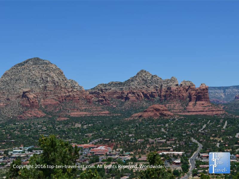
I have been exploring the many breathtaking trails around Sedona since moving to neighboring Flagstaff. After just a few hikes, I quickly decided that seeing the enchanting red rocks is even more bucket list worthy than the Grand Canyon. And yes, every visiting relative from out-of-state agrees that this area is stunning. These incredible views can be explored through various means, my preferred being hiking. However, the summer is not the best season to plan any of the more lengthy adventurous hikes. This time of year is actually a great time to explore the non hiking alternatives.
After living in the region for several years, I learned really quick that a long hike is not the way to go during the hot summer season. Temps here are not as hot as Phoenix but they can soar into the 90’s pretty regularly. Long trails are also not a great choice for first time visitors unfamiliar with the terrain. If you are looking to keep it short & sweet, yet still enjoy the breathtaking red rock scenery, you can explore via one of my recommended easy/moderate hikes.
These hikes I will be recommending are best suited for those with little time, those wanting to avoid a long trek in the hot sun, and those looking for something on the easier side. I’ve listed a few of my favorites, keeping the total distance under 5 miles.
Doe Mountain
Doe Mountain is a moderately challenging hike which involves a short & steep climb up to a scenic mesa. This underrated hike offers some of the biggest views in town, with minimal effort required. Although the trek involves a series of steep switchbacks, the total distance is just 0.7 miles each way.
The extraordinary summit views more than make up for the intense cardio workout. I find this one a bit scary as there are some pretty steep drop offs. I don’t recommend this one for anyone scared of heights. For anyone else, it’s easily one of the best bang-for-your-buck trails in town.
The panoramic red rock views from the summit are so incredible – few hikes offer this grand of a view in exchange for so little time and effort. Once you get to the top, you can walk around, check for signs of wildlife, and enjoy unending photo opportunities, all in a really quiet setting totally away from everything touristy. As I like to hike new trails all the time, I rarely come back to the same trail more than a few times. This is one of my go-tos when I am seeking big views.
- Distance: 1.7 miles RT
- Difficulty: Moderate
- Elevation gain: 400 ft.
- Location: 97-99 Callisto Ct
Devil’s Bridge
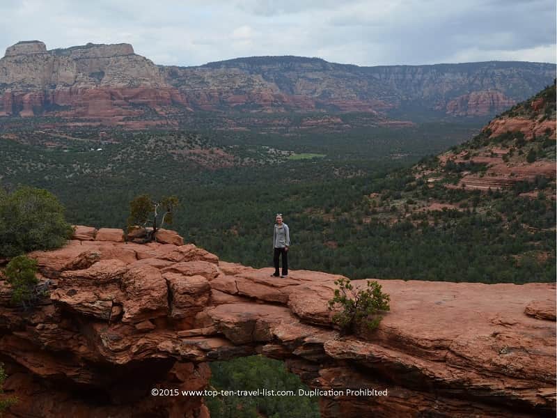
Devil’s Bridge is one of the most used trails and for good reason! Tourists love the ending photo opp which brings you to the area’s most striking feature: the largest sandstone arch. Walking across this arch is an exhilarating experience! Assuming you are not scared of heights (there is a very steep drop off), you can have someone on the other end take your picture.
Luckily, people here are very friendly here so you should have no problem finding someone nice enough to take your photo. The bridge is not as narrow as it looks, however, you’ll have a blast showing friends and family members your “big feat.”
Despite being crowded pretty much the entire year and the hassle of finding parking (arrive early!), this is one of the region’s most bucket worthy hikes. It’s worth the hassle at least once.
Note: If you do not have a high clearance vehicle, you will need to start your hike on the Mescal/Chuck Wagon trail, adding about 2 miles to your total distance, for a total of around 4 miles. Don’t worry as the extra mileage is very scenic, easy in intensity, and peaceful! Overall, I would rate this hike as moderate in intensity as only the ending portion involves a bit of a scramble uphill.
- Distance: 4 miles RT (Mescal-Chuckwagon to Devil’s Bridge)
- Difficulty: Moderate (due to a rough/steep climb at the end)
- Elevation gain: 400 ft
- Location: Drive to Dry Creek Road and turn right at the stop sign onto Long Canyon Road. Turn right and drive 0.2 miles to the Mescal Trailhead on the right. Use the Mescal-Chuckwagon trail connection to reach Devils Bridge Trailhead.
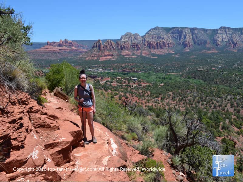
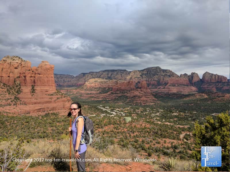
Airport Mesa
Airport Mesa is a pretty unique trail to add to your hiking bucket list. First off, the scenery is really spectacular (see more pics and read more about my experience). The views are really jaw dropping – particularly during the first section of the trail, although the very steep scary drop offs might be too much for those afraid of heights.
Prominent red rock formations surround you in every direction and the trail is relatively peaceful and quiet. Second, the desert plant life here is extraordinary, with dozens of healthy bright green prickly pear lining much of the trail. It’s my favorite trail for seeing cacti.
Third, this hike is considered to be one of 4 vortex hikes. The others are: Bell Rock, Boynton Canyon, & Cathedral Rock. In this highly spiritual region, a vortex site is said to possess special energies. This is due to an unusually high concentration of energy naturally swirling up from the earth. As this is a New Age theory, there really is no proof, although many claim to feel a sense of peace or healing after visiting these sites.
The entire Sedona region is technically a vortex. However, these 4 hikes I mentioned are said to be areas of intense concentrated energy. Lastly, Airport Mesa is one of the top sunrise/sunset destinations. The hike is just over 3 miles and not overly difficult, so it’s a contender during the warmer months.
- Distance: 3.5 miles RT
- Difficulty: Moderate
- Elevation Gain: 300 ft
- Location: 538 Airport Rd.
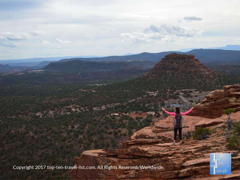
Teacup/Sugarloaf Summit
The magnificent Teacup/Sugarloaf Summit loop is so beautiful, peaceful, and conveniently close to Uptown, yet still somehow forgotten. Quite a shame as the summit views are so enchanting. For jaw dropping scenery like you have never seen before, do consider adding this hike to your itinerary. When I first hiked this one, I was so shocked on how little traffic it received. The little effort required to take in such amazing views is crazy.
Most of the trek is very easy and relaxing with ongoing views of dramatic rock formations including the towering Coffeepot rock. Every formation’s name is based on the shape it resembles. In the case of Coffeepot, it resembles a French Press.
Combining the Teacup with the Sugarloaf Summit (a short 0.3 mile climb to a breathtaking overlook) adds little to your total distance, yet the payoff is huge considering the stunning 360 degree panoramic red rock views. Just when you think the views could not possibly get any better, they do. This hike is so amazing that it is one of the few that I deemed spectacular enough to complete numerous times.
- Distance: 1.9 mile loop
- Difficulty: Easy
- Elevation gain: 400 ft
- Location: Buena Vista Dr.
Cookstove
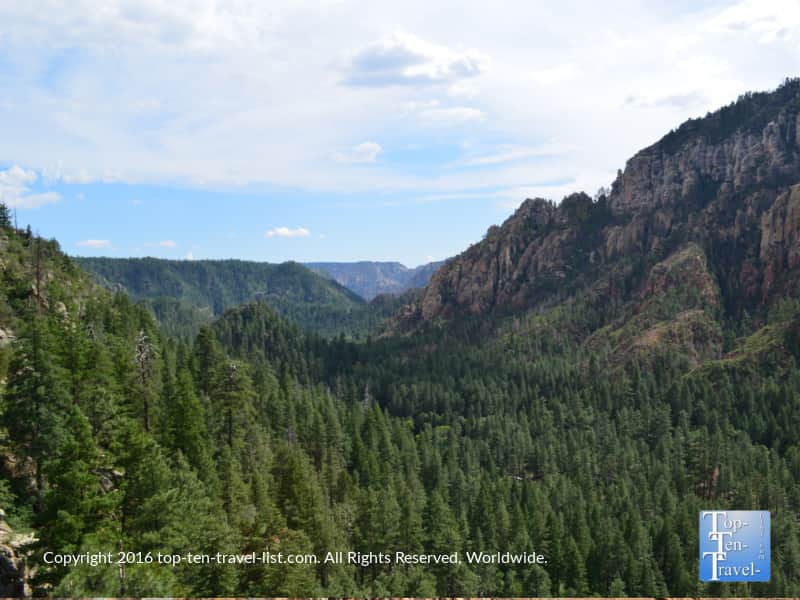
While you visit this region to see the amazing red rocks, the dramatic cliffs and pine forests of beautiful Oak Creek Canyon are just as impressive. If you are coming from Flagstaff, you will take a fabulous road known as Oak Creek Canyon. For 14 miles, this drive leads you through a variety of incredible landscapes including colorful rock formations, tall ponderosa pine forests, and even deciduous forests which turn beautiful hues of red and yellow come fall.
Oak Creek is home to a diverse variety of plant life, and thus, the views are quite different. Due to the extreme elevation changes (4000-7000 ft), you will get to witness the scenery change from green pines to stunning red rocks. It’s a really cool experience (much more exciting than visiting the Canyon in my opinion).
My favorite thing to do while driving this road is stopping to hike the Cookstove. It’s an underrated trail which is passed up in favor of the West Fork (another great but I prefer the big pine views via the summit of Cookstove). After a decent climb, you will be treated to some great overviews of the canyon.
The climb up is really steep but just under a mile, plus it’s really shady. I prefer shorter treks during the summer even if they are a bit harder in intensity – it’s much harder to hike for longer with the intense sunlight in your face. This hike remains a peaceful gem and is probably one of a handful that I hiked completely alone.
- Distance: 0.7 miles out-and-back
- Difficulty: Moderate-Difficult, depending on current fitness level
- Elevation gain: 450 ft
- Location: Mile marker 387 on Hwy 89a