10 Easy Waterfall Hikes Near Asheville, NC
Disclaimer: We are not paid to promote any restaurant, hotel, activity, product, or attraction. All opinions are subjective and based on our personal experience. Your experience may be different.
Asheville is an ideal destination for exploring the beautiful Blue Ridge region of Western North Carolina. There are 100’s of miles of incredible hiking trails, with over 200 waterfalls to enjoy, within an easy drive of the city. Transylvania County, “the land of waterfalls,” offers no shortage of spectacular waterfall hikes, most of which are within 40 min of the downtown limits. Fortunately, viewing these enchanting waterfalls often requires little to no effort.
I am an avid hiker and nature lover. Since moving to Asheville, I have spent most of my weekends checking out the best hikes and waterfalls in the Blue Ridge region. This guide will focus on my favorite hikes, all coming in under 2 miles RT and easy in intensity. Drive time is less than an hour, so an easy daytrip. Parking is free unless noted otherwise.
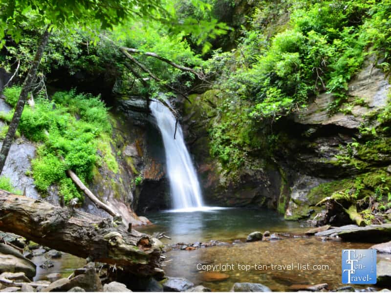
1. Roaring Fork Falls
- Distance from Asheville: 1 hour
- Address: 208 Busick Work Center Rd, Burnsville, NC 28714
- Hike Distance: 0.6 miles each way
- Waterfall height: 100 feet
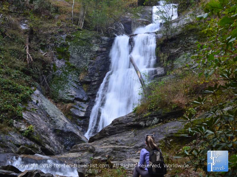
This gently cascading waterfall is often overlooked as nearby Blue Ridge attractions tend to draw all the tourist traffic. The hike to Roaring Fork consists of an easy half mile stroll along an old logging road. There is barely any elevation gain as the majority of the trail follows an easy gravel path. Near the end, there are some exposed tree roots and rocks to climb, however, little more than light caution needs to be taken. This hike is very shady with beautiful views of the Pisgah National forest throughout. It’s rare to see more than a handful of hikers thanks to its’ remote setting.
This waterfall is gorgeous, one of the most photo worthy in Western North Carolina in my opinion. The pretty greenery framing the falls is really refreshing and picture-perfect. Luckily, there are not many tourists getting in the way of photos, unlike popular attractions like Looking Glass Falls where it is near impossible to capture the beauty all to yourself. Note that the water flow will be most dramatic following heavy rainfall.
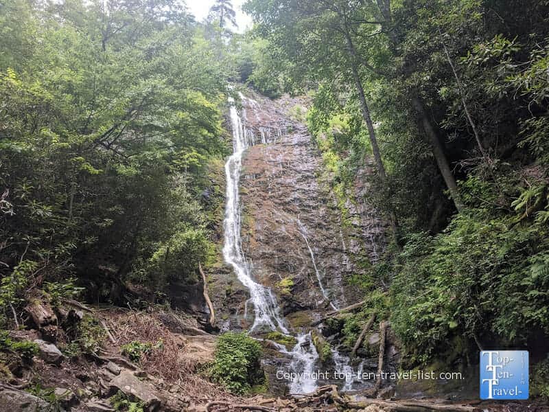
2. Tom’s Creek Falls
- Distance from Asheville: 50 min
- Address: 1250 Huskins Branch Rd, Marion, NC 28752
- Hike distance: 0.5 miles each way
- Waterfall height: 80 feet
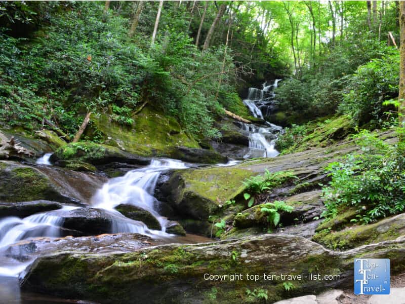
This hidden gem is located off-the-beaten path (about 9 miles from the BRP) and tends to be visited more by locals than tourists. This keeps the vibe attractively tranquil and rustic. Tom’s Creek is located within the Pisgah National Forest near the town of Marion. A nice quiet woodsy trek of a half mile leads you to a breathtaking multi tiered, 80 foot waterfall. One of the interesting aspects of this hike is the glistening rocks found near the falls. Once home to a mica mine, the mica now sparkles in the sun, creating a unique setting not found elsewhere. There is a nice viewing platform here for taking photos.
While more stunning after a heavy rainfall, this waterfall is beautiful anytime of the year. During the fall season, you will be surrounded by colorful foliage. Wintertime, you may see icicles and fresh snow surrounding the falls. Frozen waterfalls truly are an enchanting sight to behold if you can time your visit just right. If you are looking for absolute solitude, winter is the best time to embark on this and any other WNC adventures.
3. Courthouse Falls
- Distance: 1 hour
- Address: Courthouse Creek Road (FSR 140)
- Hike distance: 0.3 miles each way
- Waterfall height: 45 feet
Another secluded gem in the Pisgah Forest is gorgeous Courthouse Falls. With this one, you have to check the National Forest website to ensure that the road to the falls is open, or risk turning this easy nature stroll into a moderate hike. Heads up – if the road is closed, you will have to walk the 2.5 mile gravel road, in addition to the hike, making this hike 5+ miles. Assuming the road is open, the hike to the falls is just over a half mile round-trip and flat for the most part besides a small steep staircase right before your reach the falls. The waterfall is a mere 45 feet, but one of the most scenic in WNC as it cascades beautifully into a deep pool in a scenic cove.
Be aware that the drive to get to this waterfall is more difficult than the hike itself. Although 4WD is not required, the 2.5 mile long road is very bumpy. Also, finding the trailhead is a bit of a hassle, especially with no other cars in the area. Look for little cutout in the woods and a small trail sign on FSR 140 (about 2.5 miles in).
4. Hickory Nut Falls
- Distance from Asheville: 1 hour
- Address: Highway 64/74A Chimney Rock, NC 28720. Fee: $17 per adult, $8 per youth
- Hike distance: 0.7 miles each way
- Waterfall height: 404 feet
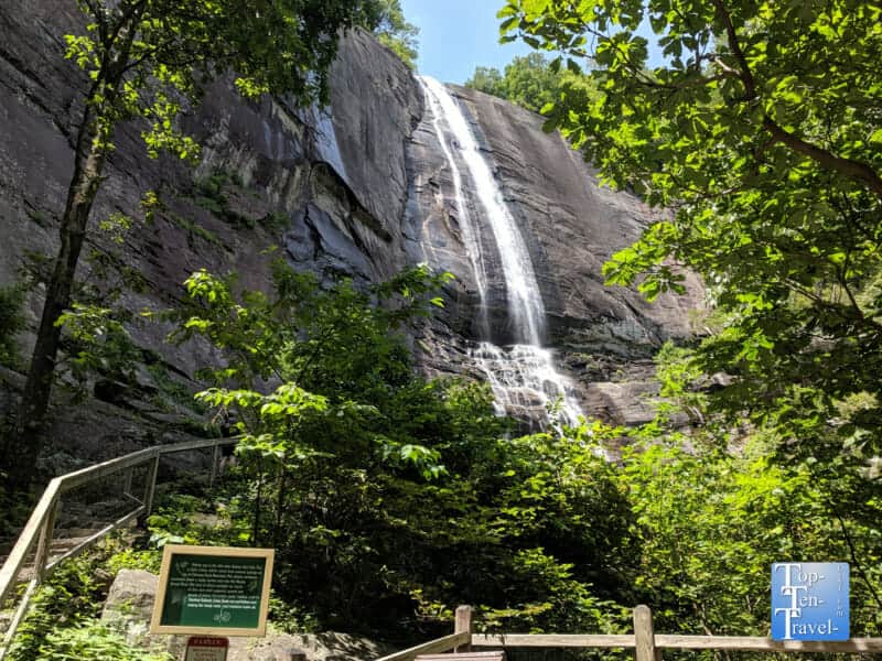
The state’s 2nd tallest waterfall is accessed via hiking an easy 0.7 mile out-and-back trail at Chimney Rock State Park. The spectacular 360 degree views atop Chimney Rock (requires a steep, yet exhilarating 499 step climb!) is alone enough to warrant a visit to this WNC gem. Many tourists leave after working up a sweat on the stair climb. Don’t let this be the case! This 404 foot beauty was featured in The Last of the Mohicans. There are some pretty cool photo opps here where you can get up close and personal with the falls and even feel the cool mist – a real treat on a hot summer day!
The trail is just under a mile and a half RT and is mostly flat with a small staircase and a few uphill sections. As this trail is heavily used by tourists, there are plenty of benches, as well as picnic tables along the way. Fall is the best time to visit as the trail meanders through a leafy deciduous forest. Summer is pretty spectacular too as the rhododendrons are in bloom. If quiet is what you seek, treat yourself to a winter walk where you may be lucky enough to see a rare frozen waterfall.
5. Mingo Falls
- Distance from Asheville: 1 hour 20 min
- Address: 71 Big Cove Road, Cherokee, NC
- Hike Distance: 0.4 miles out-and-back
- Waterfall height: 120 feet
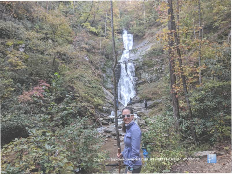
One of the tallest waterfalls in the Southern Appalachians, beautiful Mingo Falls, rises 120 feet and cascades down 200 feet of boulders, rocks, and fallen trees. The hike is super short at just a quarter of a mile, although it does includes 161 steep steps. The trek might not be suitable for those with knee issues. Nothing too challenging, but a nice little workout if you are seeking one. A wooden viewing bridge offers a breathtaking glimpse of the falls. Mingo is located on the Cherokee Indian reservation, just 5 miles outside of the Smoky Mountains National Park. If you are taking the Blue Ridge Parkway, you will exit Milepost 469.1 in Cherokee.
Although a bit crowded, Mingo is definitely one of the state’s most incredible waterfalls. As the tallest and most easily accessible waterfall in the Smokies, you can bet this one is busy most of the year. A worthy daytrip from Asheville for sure, especially if you are planning on exploring the Smoky Mountains or other Cherokee attractions (Soco Falls, Cherokee casino).
- 1
- 2